The hike
Where does the Fushimi Inari hike go?
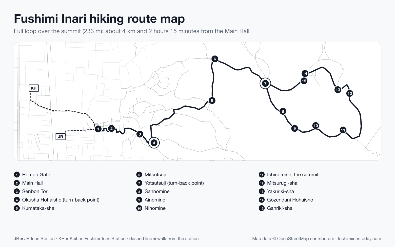
The full loop over the summit is about 4 km and takes about 2 hours 15 minutes. Yotsutsuji, about 30–40 minutes' walk from the main hall, is a common place to turn back.
Compare the three hike options and their timesThe stone steps are slippery after rain. Wear shoes with grip.
Where is each stop on the route?
Tap a stop to find it on the map, or tap a number on the map to find the stop.
- Compare JR and Keihan
- Compare JR and Keihan
- See the Romon Gate guide
- See the Main Hall guide
- See the Senbon Torii guide
- See the Okusha Hohaisho guide
- See the Kumataka-sha guide
- See the Mitsutsuji guide
- See the Yotsutsuji guide
- See the Sannomine guide
- See the Ainomine guide
- See the Ninomine guide
- See the Ichinomine, the summit guide
- See the Mitsurugi-sha guide
- See the Yakuriki-sha guide
- See the Gozendani Hohaisho guide
- See the Ganriki-sha guide
Distances are along the drawn route from the Romon Gate (OpenStreetMap). The line runs from the gate through Senbon Torii to Yotsutsuji, then round the summit loop and back to Yotsutsuji. "Busier" or "quieter than usual" compares each stop with its own typical week, not with other stops. Stops marked less reliable have thin data.
Can you save the map to your phone?
Yes. Save this image before you start and you can check the route without a connection. It shows the whole route with every stop numbered.
Which route should you take?
Four model routes from the Inari Hanei-kai, the local shop and business association. Times are theirs; each route has its own page here, with a link to their original page in Japanese.
01
Mt Inari loop
Time About 2 hours 15 minutes
Through Senbon Torii and past Yotsutsuji to the summit and back down, about 4 km. Take your time and wear good shoes.
See every stop: Mt Inari loopSource: Inari Hanei-kai, 稲荷山散策ルート (Japanese)02
Quick visit
Time About 30 minutes
The main hall, Senbon Torii and Okusha Hohaisho with the Omokaru stones. For when you're short on time.
See every stop: Quick visitSource: Inari Hanei-kai, お手軽お参りルート (Japanese)03
History walk
Time About 20 minutes
Traces around the station: the old Kyoto tram line, the oldest surviving building of Japan's national railway, and Azumamaro Shrine.
See every stop: History walkSource: Inari Hanei-kai, 歴史探訪ルート (Japanese)04
Jizo statue walk
Time About 1 hour
The small Jizo statues of the neighbourhood, including Nurikobe Jizo, visited by people praying to be rid of toothache.
See every stop: Jizo statue walkSource: Inari Hanei-kai, お地蔵さん巡りルート (Japanese)
When should you start the hike?
Best window: before 8:00 or after 18:00. Tuesday to Thursday mornings are the quietest.
See today's quiet hoursLast updated: